| |
|
|
|
|
ACQUISITION |
Purpose built for the Admiralty
|
|
COMMISSIONED |
1.5.1943
|
|
CLOSED |
|
|
PAID OFF |
14.8.1946 |
|
|
|
|
C.O./O.I.C. |
|
|
|
|
|
FUNCTION |
Deck landing training school; p.L.c.Q. training.
T.B.R. Training
Aircraft Handling and Fire Fighting school
|
|
ADDRESS |
R.N. Air Station,
East Haven,
Carnoustie,
Angus,
Scotland.
|
|
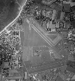
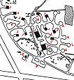
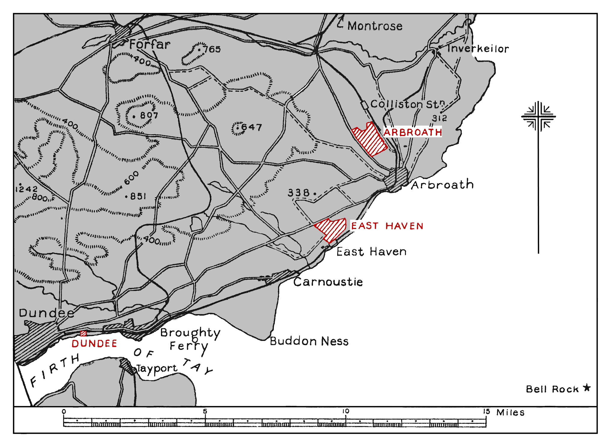
LOCALITY
|
The airfield lies between the main Arbroath-Dundee road
and the coast; ½ mile N. of
the coastal village of East Haven. Arbroath lies 3 miles
N.E. by E. Dundee lies 11 miles W.S.W.
|
|
LANDMARKS |
Buddon Ness, the N. entrance point of the Firth of Tay,
distant 4 miles S,W.; the Arbroath-Dundee road forming the
N.W. boundary and the coastal railway passing 400 yds. from
the S.E. boundary.
|
|
ROAD AND RAIL ACCESS |
Main road from the airfield 'to Arbroath and Dundee. Road
from airfield to railway station at East Haven, on the line
from Arbroath to Dundee; Stores not requiring a crane should
be routed to. East Haven railway station.
Personnel and heavy stores to Arbroath railway, station. |
|
|
|
|
| |
|
|
|
|
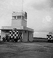
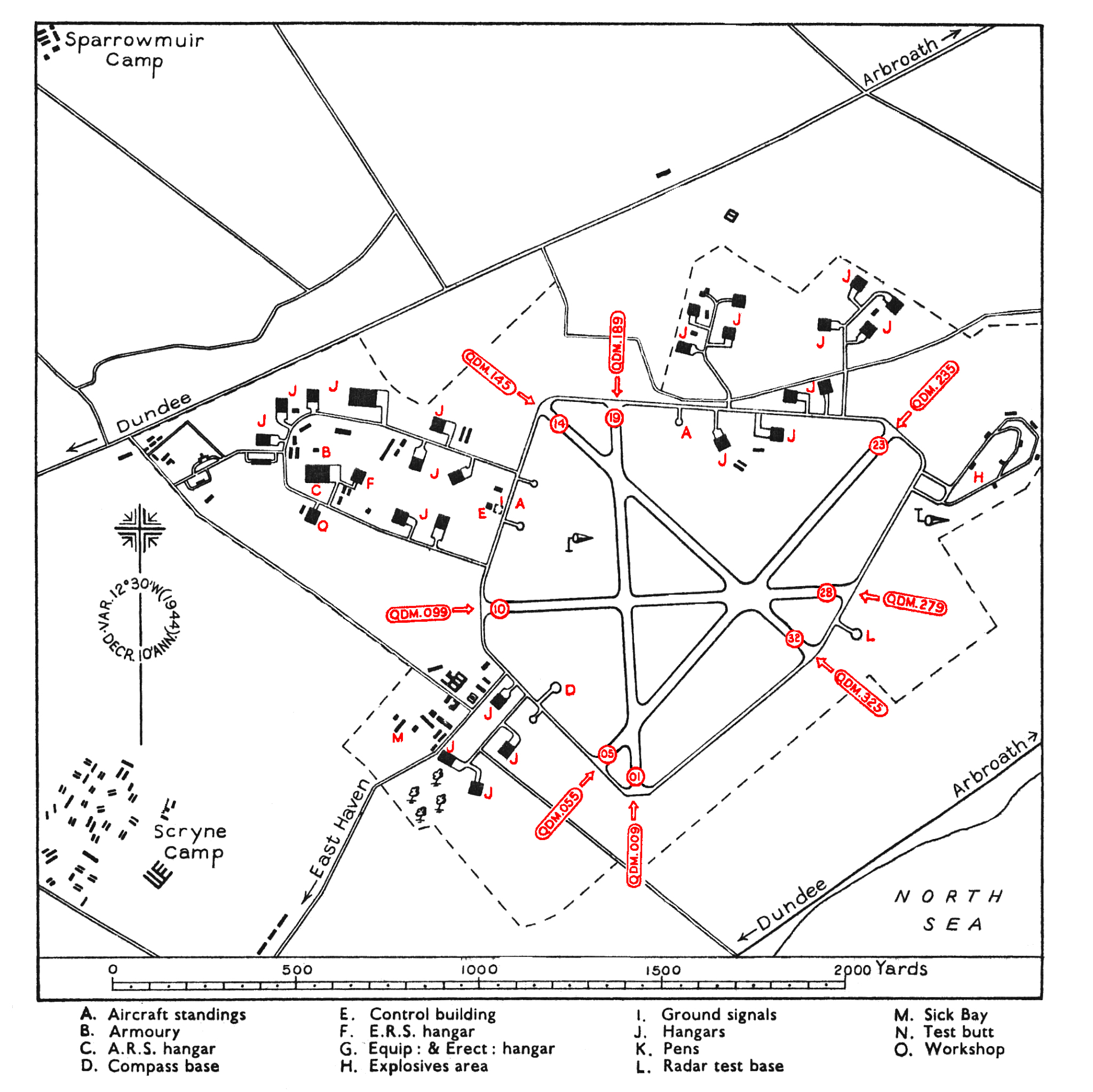
CONTROL |
Control building outside perimeter track, on the N.W.
side of the landing area.
Ground signals area immediately in front of the Control
building.
|
|
ELEVATION |
75' above M.S.L.
|
|
RUNWAYS |
Four, tarmac.
01/19 QDM. 009°
-189°
.... 1,060 x 30 yds.
05/23 QDM. 055°
-235°
.... 1,220 x 30 yds. Low visibility runway.
10/28 QDM. 099°
-279°
.... 1,015 x 30 yds.
14/32 QDM. 145°
-325°
.... 1,000 x 30 yds.
|
|
TRACKS |
40-ft. perimeter track.
|
|
OBSTRUCTIONS |
Navigation |
Rising land to N. and W. (600 ft. within 5 miles). |
|
Circuit |
Rising land to N.W. with hillock, 338, ft.
distant2.300yds.
N.N.W. |
|
Approach |
Best approach is to runway 05/23. Dummy Carrier Island
(H.M.S. " Spurious ") normally constitutes an
obstruction to other than controlled landings.
|
|
WIND INDICATOR |
Windsocks inside perimeter track, on W. side of landing
area, and outside perimeter track, on the E. side. |
|
|
|
|
 |
|
|
|
|
HOMING - VISUAL |
By day |
None. |
|
By night |
None.
|
|
HOMING--RADIO |
D/F |
|
|
Beacons |
|
|
APPROACH - VISUAL |
By day |
None. |
|
By night |
Airfield lighting (Naval) installed.
|
|
APPROACH - RADIO |
|
|
COMMUNICATION EQUIPMENT |
1 line M/F. (W/T.). 4 lines H/F. (R/T.). |
|
CALL SIGNS |
R/T |
|
|
W/T |
|
|
Identity letters |
|
|
|
|
|
GROUND RADAR |
|
|
|
|
|
| |
|
|
|
|
ACCOMMODATION |
At Sparrowmuir camp mile ½mile
W. and at Scryne camp ½mile
W.S.W. of the airfield.
Capacity:
|
Officers: |
154 |
|
Chiefs, P.O.s and ratings: |
1.012 |
|
W.R.N.S. Officers: |
14 |
|
W.R.N.S. Chiefs, P.O.s and ratings; |
364 |
|
|
ARMOURIES |
To accommodate 4 squadrons.
|
|
COMPASS BASE |
One, tarmac, diameter 70 ft.
|
|
DISPERSAL |
Four A/c standings off the perimeter track, to N. and W.
|
|
HANGARS |
On the N., S.W. and N.W. sides of the airfield,
connected by 40-ft. tracks to the perimeter track.
|
Number /Type |
Size |
Door Height |
Door Width |
|
4 (Squadron) |
60'x 70' |
20' |
60' |
|
8 (Squadron) |
60'x 70' |
17' |
55' |
|
14 (Storage) |
60'x 70' |
17' |
55' |
|
|
|
|
MEDICAL |
Sick Bay on S.W. side of airfield.
|
|
METEOROLOGICAL |
Office in the Control building. Full meteorological
service by Naval personnel available.
|
|
FUEL AND OIL |
|
Aviation: |
Two installations of 18,000 gallons each. |
|
M/T: |
2,000 gallons. |
|
Oil : |
4,000 gallons. |
|
|
|
|
|
TEST BASE |
Test base, aligned on Bell Rock.
|
|
TEST BUTT |
Test butt and 25-yd. range under construction.
|
|
WORKSHOPS |
One A.R.S. hangar and one Reserve Servicing hangar; each
185.' x 110' x 25':x 110'.
Workshops to 2-3 squadron scale.
|
|
VISITORS |
|
|
EXPLOSIVES |
Explosives area on the N.E. side of the airfield:
Practise Stocks to provision
2 T.B.R. and 1 F. F.' squadron.
|
|
TRAINING EQUIPMENT |
Catapult and crane being installed.
|
|
BOMBING AND FIRING RANGES |
|
|
|
Use of Monifieth Bombing Range araRunness Range when
completed. |
|
|
|
|
|
|
|
Information taken from CB 4368 B. Admiralty Handbook
of Naval Air Stations Aug. 45 |
|
 |
List of first and second line squadrons, station
flight and other flying units based at this location |
|
|
|
|
731
|
|
|
767
|
|
|
768
|
|
|
769
|
|
|
826 |
|
|
 |
|
PAGE UNDER
CONSTRUCTION
Click here for a list of
Primary sources
Additional sources:
Admiralty Fleet Orders:
Confidential Admiralty Fleet Orders:
|
|
|
| |
|
|
|


Comments (0)