| |
|
|
|
|
ACQUISITION |
Transferred from R.A.F. for satellite airfield to RNAS
Stretton 13 August 1942 [1]
|
|
OPENED |
|
|
COMMISSIONED |
14 June 1943 as an independent command bearing the
ship’s name 'GODWIT' with accounts carried in H.M.S.
“BLACKCAP”
01 April
1944 as H.M.S. GODWIT |
|
PAID OFF |
28 February 1947
|
|
CLOSED |
28 February 1947
|
|
COMMANDING
OFFICER |
Commander
RNVR (P) J. B. W. Pugh, OBE, AFC 14 June 43
|
|
FUNCTION |
Central Naval Instrument Flying Training School, with
accessory training.
|
|
TENDERS |
R.N.A.S. Hinstock has the temporary use of two airfields
in connection with Instrument Flying Training:-
1. Weston Park (by arrangement with M.A.P. ) situated 12
miles S.E. Of Hinstock and 8 miles N.W. of
Wolverhampton.
2. Bratton (by arrangement with Air Ministry) situated
6½ miles S.S.W. of Hinstock and 8 miles E. of
Shrewsbury.
|
|
ADDRESS |
R.N. Air Station,
Hinstock,
Market Drayton,
Shropshire.
England |
|
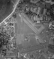
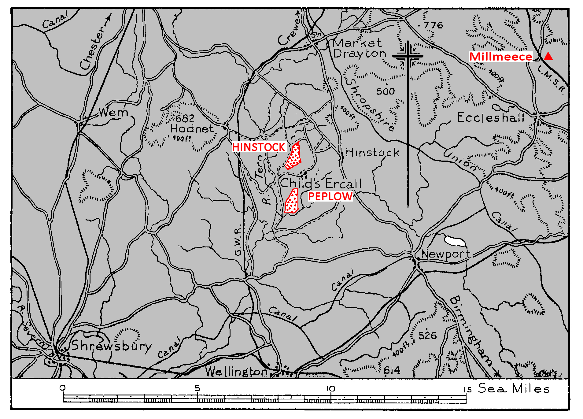
LOCALITY |
The airfield lies 4 miles S. by W. of Market Drayton and
1¾ miles W. of the village of Hinstock. Stoke on Trent lies 13 miles N.E.
and Shrewsbury 11½ miles S.W. Birmingham lies 30 miles S.E.
|
|
LANDMARKS |
The Shropshire Union canal, running from Birmingham,
through Market Drayton to Chester, passes 2½ miles
N.E.; the river Tern, flowing S. towards its junction,
10½ miles S.W., with the Severn, passes ¾ mile W.
The G.W.R. line to Market Drayton runs 2 miles W. of the
airfield. |
|
ROAD AND RAIL ACCESS |
Secondary road to Hodnet, and to Hinstock amend the main
Market Drayton road. Hodnet railway station, 2¼ miles
W.N.W., on the G.W.R. line to Market Drayton, where
there is a junction with the L.M.S.
|
|
| |
|
|
|
|
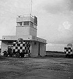
CONTROL |
Control building on NW, side of landing area. Keeps
watch on Naval Safety wavelength. Combined Control with
adjacent R.A.F. Stations by tie-line and combined
left-hand circuits with R.A.F. Peplow.
|
|
SIGNALS |
Ground signals area close S. of Control building. Sodium
lighting for fog conditions.
|
|
ELEVATION |
265' above M.S.L.
|
|
RUNWAYS /LANDING AREA |
One, heavy steel track.
04/22 QDM. 037°/217° .... 1,400 X 50 yds.
The airfield is grass surfaced with dimensions N./S.
1,600 yds. N.E./S.W. 1,100 yds. (Part only serviceable.)
|
|
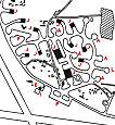
TRACKS |
A 25 ft. perimeter track (to be widened to 40 ft.)
bounds the landing area from the centre of its W. side,
round the N. end and down the E. side. It gives access
to all station buildings and hangars. Extension of
perimeter track in progress.
|
|
OBSTRUCTIONS |
Navigation:
Circuit:
Approach:
|
None.
Avoid crossing R.A.F. Peplow, lying I mile S.S.E.
90 ft.
W/T. masts at S.E. extremity of the airfield. |
|
APPROACH |
Not known
|
|
WIND INDICATOR |
Windsock on the E. side of the landing area, near the
compass base. |
|
|
|
|
 |
|
|
|
|
HOMING - VISUAL |
By day:
By night:
|
Not known
Not known
|
|
HOMING--RADIO |
D/F: Beacon:
|
One H/F (second H/F, also VHF to be installed). |
|
Navigational: |
YG Beacon.
251M. Beacon.
Std. Beam Approach. Type 93 (Naval B.A.). Type 257 (BABS)
to be installed |
|
APPROACH - VISUAL |
By day:
|
Not known
|
|
By night: |
Portable equipment (2 floodlights) on demand.
|
|
APPROACH - RADIO |
Not known
|
|
COMMUNICATION EQUIPMENT |
W/T and R/T:
VH/F:
|
I line M/F. (not yet available). 2 H/F Control
channels (" A " and " B "). VHF (to be installed). 2
lines H/F. |
|
GROUND RADAR |
Not known
|
|
| |
|
|
|
|
ACCOMMODATION |
Officers quarters at Hinstock Hall, 1¾ miles E.
Ratings quarters at Childs Ercall,½ mile S.
W.R.N.S. quarters at Steppes farm, Childs Ercall.
Capacity:
|
Officers: |
130 |
|
Chiefs, P.O.s and ratings: |
363 |
|
W.R.N.S. Officers: |
7 |
|
W.R.N.S. Chiefs, P.O.s and ratings; |
144. |
|
|
ARMOURIES |
To accommodate 2 squadrons.
|
|
COMPASS BASE |
One, tarmac. Diameter 70 ft.
|
|
DISPERSAL |
5 bomber type A/C standings.
|
|
HANGARS |
On E., S.E. and N.W. sides of the landing area.
|
Number /Type |
Size |
Door Height |
Door Width |
|
2 Pentad (Squadron) |
185' x 110' |
25' |
100' |
|
5 Mains (Squadron) |
60' x 84' |
17' |
55' |
|
1 Mains (Squadron) |
60' x 70' |
17' |
55' |
|
5 Super Blister (Squadron) |
91' x 67' 5" |
20' 4" |
57' 23" |
|
|
|
|
MEDICAL |
Sick Bay at The Hall, Childs Ercall, ½ mile S. of the
airfield. First Aid
facilities at the airfield.
|
|
METEOROLOGICAL |
Office in Control building. Full meteorological service
by Naval personnel available .
|
|
FUEL AND OIL |
|
Aviation: |
24,000 gallons. Two further installations of
8,000 gallons each to be provided. |
|
M/T: |
2,000 gallons |
|
Oil : |
2,000 gallons |
|
|
TEST BASE |
A/c. Radar test base to be provided.
|
|
TEST BUTT |
None.
|
|
WORKSHOPS |
One large Reserve Servicing and one large A.R.S. hangar
to be provided. Workshops to 2 3 squadron scale.
|
|
EXPLOSIVES |
Explosives area at N. end of airfield.
|
|
BOMBING AND FIRING RANGES |
Not known |
|
|
|
|
|
|
|
Information taken from CB 4368 A. Admiralty Handbook
of Naval Air Stations Aug. 45
|
|
 |
List of first and second line squadrons, station
flight and other flying units based at this location |
|
|
|
|
702 |
Instrument Flying Training & Checking Squadron
Squadron reformed as an offshoot of No.758 Squadron
at Hinstock on o1.06.11945.
Squadron personnel took passage to
RNAS Schofields, Australia seven weeks later.
Equipped with.
Oxfords and Harvards.
|
|
729 |
Instrument Flying Training squadron
Squadron
formed as an offshoot of No.758 Squadron 0.011945.
Squadron personnel took
passage to
RNAMY Coimbatore, India
on 16.p4.1945, without aircraft.
Equipped
with.
Oxfords and Harvards.
|
|
734 |
Engine Handling Unit.
Moved here from
RNAS Worthy Down
21.08.45 Operated out of Hinstock's satellite at
Peplow. disbanded on 21.02.1946.
Initial equipment Whitley GR.VIIS, planned to re-equip with Fortress and Lancaster
|
|
758 |
Naval Advanced Instrument Flying Training Unit.
Moved here from
RNAS Donibristle on 15.08.1942.
Disbanded at RNAS Peplow 14.05.1946, to become 'B' Flight of 780 Squadron. Mainly equipped with Oxfords; also received Anson, Harvard IIb, Reliant, Tiger Moth, and Wellington XIs.
|
|
780 |
Advanced
Flying Training Unit
Reformed at Hinstock on 28.03.1946.
Based at
the
Peplow satellite.
On 14 May 1946 the remnants of
No.758 Squadron were absorbed to form 'B' Flight;
this moved to RNAS Crail on 17.121946.
780 squadron moved to
RNAS Donibristle
27.031947
Equipped
with Oxfords, Harvards, Fireflies, Tiger Moths, and Lancasters.
|
|
798 |
Advanced
Single .Engine Conversion & Refresher Flying
Training Unit.
Moved here from
RNAS Halesworth 28.11.1945.
Disbanded on 18.03.1946.
Equipped with an assortment of Barracudas,
Fireflies, Harvards, Seafires, and Tiger Moths.
|
|
|
|
 |
|
The
airfield was built a secret Relief Landing Ground (RLG) for
RAF Exeter and great trouble was
RN use of the airfield
By the time
the airfield opened at the end of May 1942 the need for a
secret RLG had passed
Commissioned as an RN Air Station
By the end
of 1942 it was clear that the RAF had no use for the
Charlton Horethorne RLG and the airfield was transferred to
the Admiralty; the station commissioned as H.M.S. HERON II
on New Year’s Day 1943.
Returned to RAF Control
In the
spring of 1945 the Admiralty agreed to exchange Charlton
Horethorne for the RAF field at
PAGE UNDER
CONSTRUCTION
Click here for a list of
Primary sources
Additional sources:
Admiralty Fleet Orders:
[1] 4232/42 —R.N. Air Station,
Ollerton—School for Instruction in Blind Approach and
Instrument Flying
5220/42 —R.N. Air Station, Olierton—Renamed Hinstock
3271/43—R.N. Air Station, Hinstock—Transfer of Accounts
2587/43 —R.N. Air Station, Hinstock—Commissioning as
Independent Command
Confidential Admiralty Fleet Orders:
|
|
|
| |
|
|
|
|


Comments (0)